GeoSurf vs. QGIS

Overview
ProductRatingMost Used ByProduct SummaryStarting Price
GeoSurf
Score 7.5 out of 10
N/A
GeoSurf is browser toolbar that enables users to get the local perspective from more than 110 global locations. It is often used by online media professionals (buyers, campaign managers, sales, affiliates, and compliance teams) to view geo-targeted ads and web content. This way, they can easily validate and monitor campaigns, see who is bidding on localized ad placements, generate new sources of business, and enhance current marketing activities. The interface is a straight-forward toolbar which…
$89
month
QGIS
Score 9.8 out of 10
N/A
QGIS (formerly Quantum GIS) is a free and open source geographic information system.N/A
Pricing
GeoSurfQGIS
Editions & Modules
Gold Package
$89
month
Platinum Package
$139
month
Diamond Package
$199
month
QGIS
Free
Offerings
Pricing Offerings
GeoSurfQGIS
Free Trial
NoNo
Free/Freemium Version
NoYes
Premium Consulting/Integration Services
NoNo
Entry-level Setup FeeNo setup feeNo setup fee
Additional DetailsInterested in Enterprise plan? Contact the vendor for details.
More Pricing Information
Community Pulse
GeoSurfQGIS
Considered Both Products
GeoSurf
Chose GeoSurf
I have not had occasion to use any other products similar to GeoSurf, but have been very satisfied with the power, speed, and reliability that GeoSurf offers, and based on that experience would tend to return to GeoSurf should the need come up to rely on similar features in the …
Chose GeoSurf
Hola is a great program, but would sometimes cause issues and not revert back to a US geo. We have not experienced these issues with GeoSurf and I feel the interface is just as easy to use.
Chose GeoSurf
Past experience made me want to use both GeoSurf and TrustedProxies.com for slightly different advantages. Budgets forced us to choose only one of these services and other team members made the final choice to go with GeoSurf.
Chose GeoSurf
Geosurf blows them out of the water in terms of features and liability. Freedom offers a cheaper cost but when you are working for a big company it is time to bring out the big guns and that is where GeoSurf comes in. Reliable is an understatement for sure.
Chose GeoSurf
We have tried Opera VPN and some other VPN solutions (OVPN). These alternatives, are not so stable or user-friendly and have fewer country servers.
Chose GeoSurf
GeoSurf provides more countries. PIA is more respected in the privacy space.
Chose GeoSurf
We started using Zenmate in the US because Geosurf didn't work in Chrome for US IP addresses for several months. Zenmate is free, but has limited locales.
Chose GeoSurf
GeoSurf operates their own server throughout many data centers distributed around the globe. They boast a high level of reliability and security, so much so, that they legally bind their agreements to ensure that search history or any other data will never be released or used …
Chose GeoSurf
Prior to my work at this company, I was a GeoEdge customer. Overall, I the products are largely the same in ease of use, reliability and features. I don't have a strong preference for either product. If I were to find myself at another company looking for this type of tool, I'd …
Chose GeoSurf
I have not used an alternative. My employers have provided this tool.
Chose GeoSurf
Geosurf is by far the best due to the simplicity and ease of using the mobile app and browser toolbar.
Chose GeoSurf
It's just better - GeoSurf rocks.
QGIS
Chose QGIS
ArcGIS is extremely expensive, especially for small businesses.
The QGIS learning curve is smoother.
ArcGis demands more from the hardware.
Chose QGIS
QGIS is open source and freely available for Windows and Mac iOS Geographic Information System Software. QGIS is highly customizable as per project requirements and different application usage. QGIS has ample tools and plugins that are useful for the analysis of raster and …
Chose QGIS
Handling ESRI licenses was not an easy task for our organization as we had a large number of users that needed access to GIS capabilities on a very occasional basis. R requires a lot of coding to get a decent-looking map. QGIS hits the spot when it comes to visual …
Chose QGIS
We've used MapInfo, but it is expensive and lacks the wide support that QGIS has. It also doesn't slot in that well with the open-source stack that we use to develop our online GIS tools.

We've also evaluated Esri's Arc products. Fantastic tools, but a) exorbitantly expensive, …
Chose QGIS
Frankly, QGIS is an inferior tool as compared to ArcGIS as ArcGIS is a market leader in spatial data analysis, offers a family of GIS Suite catering to different needs, has a huge repository of training exercises and tutorials, an organized catalog of data if you need further …
Chose QGIS
We explored ArcGIS a bit and realized that we couldn't afford this approach. We fully realize it's a more complete product offering, but QGIS offered all the needed features for our business requirements. We were able to do online mapping using QGIS exports and Mapbox.com for …
Chose QGIS
I learned GIS with ArcGIS and have used ArcGIS longer than QGIS. Both programs have essentially the same functionality. However, QGIS is free, while users need a license for ArcGIS (individual licenses are available for a few hundred dollars). I really like that QGIS is open …
Chose QGIS
ESRI programs like ArcGIS are the gold standard in planning, GIS, and digital data visualization, but QGIS stands up to the ArcGIS package at a lower price point and with excellent training information. ArcGIS has very little other components not found in QGIS, and QGIS has …
Chose QGIS
Both tools are very powerful. The difference is that QGIS is open source. Experts can develop applications that suit the specific needs of certain users. A big advantage of QGIS is undoubtedly the economic cost, because Qgis is a software almost as powerful as ArcGis. I could …
Chose QGIS
First of all QGIS it is a free software in an are that has always been monopolized for big companies like ESRI, in that way QGIS bring the opportunity to know how to work with GIS and how we can manage data from so many formats in only one software. Qgis it is the best …
Chose QGIS

Each of the products have their strong points and their weak points, as well as some products being particularly adept at certain analyses or workflows. That being said, QGIS can do nearly everything all of the above products can do, and it does them for free, with continual …

Chose QGIS
QGIS vs. ArcGIS. The main reason is the price of ArcGIS. Most of the functionality is identical in both products, however, interfacing QGIS with external software allows it to dramatically increase processing capabilities.

QGIS vs. ERDAS IMAGINE. It is quite good for satellite …
Best Alternatives
GeoSurfQGIS
Small Businesses

No answers on this topic

ArcGIS
ArcGIS
Score 8.9 out of 10
Medium-sized Companies

No answers on this topic

ArcGIS
ArcGIS
Score 8.9 out of 10
Enterprises

No answers on this topic

ArcGIS
ArcGIS
Score 8.9 out of 10
All AlternativesView all alternativesView all alternatives
User Ratings
GeoSurfQGIS
Likelihood to Recommend
8.4
(0 ratings)
9.8
(0 ratings)
Likelihood to Renew
10.0
(0 ratings)
-
(0 ratings)
Usability
9.0
(0 ratings)
8.0
(0 ratings)
Availability
10.0
(0 ratings)
-
(0 ratings)
Performance
10.0
(0 ratings)
-
(0 ratings)
Support Rating
10.0
(0 ratings)
8.0
(0 ratings)
Online Training
9.0
(0 ratings)
-
(0 ratings)
Implementation Rating
10.0
(0 ratings)
-
(0 ratings)
User Testimonials
GeoSurfQGIS
Likelihood to Recommend
  • Well-suited for testing and demonstrating any product on any device for worldwide compliance.
  • Can be used for latency testing, but there are probably better solutions available.
  • Probably not as well suited for privacy; could be used like Private Internet Access, but I haven't seen general adoption of GeoSurf for that purpose. This would not help with my role at Disney though.
Read full review
Well suited:
  • To build beautiful and dynamic maps quickly.
  • To conduct quantitative and qualitative analyses.
  • To work cross-platform, as both the Windows version and the Linux version are identical in appearance and available resources.
Less appropriate:
  • To use and import files from proprietary software such as ArcGIS and AutoCAD.
Read full review
Pros
  • Simulate network requests from different parts of the world in order to see how our tech performs from different regions.
  • Test how our system behaves with when operated from client devices that identify as from different world regions.
  • Test security and fraud prevention systems that handle global IP ranges differently.
  • Operate web crawlers anonymously and legally.
Read full review
  • QGIS is free and very easy to install, and no license is required. Not having to deal with licensing issues has saved me considerable time and frustration.
  • The QGIS help community is very active, and it is easy to find answers. Although QGIS does not offer support in the way that ArcMap does, I was always able to google my question and find either a tutorial or website that solved my problem.
  • QGIS seems to crash less often than ArcMap. It is super annoying to have a program crash when you are in the middle of a project, but I have not had any issues with QGIS. Also, QGIS is updated frequently.
Read full review
Cons
  • There is no iOS app which is a big gap and we need an alternative product for such devices.
  • Our subscriptions is with shared and limited bandwidth, some users forget to turn off GeoSurf when they are done with the proxy thus incurring unnecessary costs. Would be good to have some reality checks implemented to avoid unintended long session.
  • The Android interface is little outdated, although it's still simple and quick to use. I'd prefer slightly more modern design, including usage statistics.
Read full review
  • QGIS is hard to use for beginners. A better tutorial and clearer online tutorials could improve this.
  • Labeling interface is overly complicated. Allowing users to manually add labels to relevant items could be helpful.
  • QGIS should have more "wizards" that can easily import common data points (median income, population density, etc) and cross tabulate that with other categories easily from uploaded data.
Read full review
Likelihood to Renew
It has become critical to my business.
Read full review
No answers on this topic
Usability
Easy to use and has a browser add-on
Read full review
I wasn't a GIS user at all when I started using QGIS, nor did I have any background working with data in anything other than Excel, and as a result, I struggled quite a lot in the beginning (it's not quite Google Maps). But having said that, I haven't come across anything that I couldn't do with a little help from the online community. I've done complex spatial analyses on large datasets of metropolitan cities, designed custom multi-page pdf reports that automatically cycle through different areas of an area, etc.
And the GIS staff that I've appointed, after their initial resistance, took to the tool like a fish to water, and I haven't heard them complain after starting to use the tool for a week or two.
But if you're new to GIS, be patient and invest some time to learn how to use the tool. It is absolutely worth it.
Read full review
Reliability and Availability
Never had a problem.
Read full review
No answers on this topic
Performance
Excellent speed on all of the proxies I have used.
Read full review
No answers on this topic
Support Rating
They are super responsive and helpful.
Read full review
Even though there is a no dedicated support team for QGIS (or at least we are not aware of it), there is a huge online community and a large number of forums catering to every question you may have regarding any particular functionality of QGIS. So, you have a lot of help available but you will have to sift through it on the web.
Read full review
Online Training
The program is simple to understand.
Read full review
No answers on this topic
Alternatives Considered
I have not had occasion to use any other products similar to GeoSurf, but have been very satisfied with the power, speed, and reliability that GeoSurf offers, and based on that experience would tend to return to GeoSurf should the need come up to rely on similar features in the future
Read full review
QGIS is open source and freely available for Windows and Mac iOS Geographic Information System Software. QGIS is highly customizable as per project requirements and different application usage. QGIS has ample tools and plugins that are useful for the analysis of raster and vector data. It also supports GRASS, GDAL, and SAGA tools.
Read full review
Return on Investment
  • Easy to find mistakes that would have cost a lot had they gone unnoticed.
Read full review
  • We can ingest data in any format, and convert it to industry-standard spatial files for hosting on our online GIS platform.
  • Many client projects require us to analyze and understand data before we can report on it.
  • Because QGIS is free, and the learning curve is negligible for bright GIS technicians, the ROI is practically infinite because the investment is basically zero.
Read full review
ScreenShots

GeoSurf Screenshots

Screenshot of Emulate All Browser & Devices

Validate, verify, and test web deployments on over 80 mobile devices and browser emulators with a click of a button using the GeoSurf Toolbar. Check the responsiveness and functionality of your website across different mobile devices without actually having your device on hand.Screenshot of Take Full Page Screenshots

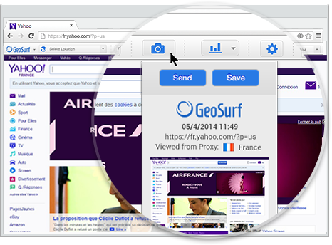
Save screenshots of publishers and advertisers’ web pages including everything above & under the fold in one click. Take multiple screenshots of a page from various locations to easily process and share geotargeted content with clients and colleagues.Screenshot of View Geo-Targeted Content

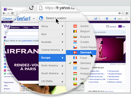
Get complete visibility into how geotargeted ads and content appear and react to interactions throughout the world. Through 120+ global gateway servers, you can view, interact with, and QA your localized placements from New York to Tokyo to Rio.